| |
PROBLEMS FOR THE CONSERVATION OF ROMAN ROADS
Examples of recent aggressions to roads in the north of Spain
(Comunicación presentada en el V Congreso Internacional de Caminería
Hispánica,
celebrado en Valencia del 17 al 22 de julio de 2000)
Isaac Moreno Gallo © 2000
TRAIANVS © 2001
The state of desertion of the former network of royal roads, after the progressive implant of modern roads, starts in the first half of the nineteenth century. These roads, in the majority with new alignments, condemn the old roadways to a marginal situation. Only the access to adjacent properties permits its surviving.
The process of re-allotment, in the richest and most productive areas of the country, initiates the real destruction of the original alignments.
Today, people don`t pay any attention, nor concede any value to those ways that don`t derive from these modern processes. Not even the suspect of its romanity, sometimes certainty, guaranties its preservation.
The romantic aspect of its existense and conservation already has been lost and the scientifical aspect has not yet started to be considered.
Under this scope, and after having covered meter by meter hundreds of kilometres of roman roads, I want to show the evidence of the actual state of indolence and desolation of these pioneer infrastructures.
I won't talk about the disappeared roads, that can only be followed on maps and on aerial photographs and which we now have to consider being roman. I will talk about well known, even by the villagers, roman roads, which recent destruction I was able to know, even observe and as an ultimate resource denounce.
Because of my investigations on the "Vía de Italia a Hispania", between Zaragoza and Astorga, I have been able to ascertain that the roman road, apparently unknown in its major part by the archaeological and historiographical science, was a very famous one.
Who reads this, don't be surprised. Over many kilometers and complete road sections of all the provinces it passes along, it is called the Roman Way, or the Roman Road, or "La Calzada" or way of the "Calzada". Very often it is represented on the cartography of all times, from the maps of López to the first "cinquentamiles" (famous maps in Spain, scaled 1:50.000), through the maps of Coello. In case of doubt, the older villagers can astonish any researcher with phrases like these: "This is the road you are looking for because it has always been called the Roman road." It is not that they know a lot about these matters, but wherever it occurs nobody has ever doubted of the road being Roman.
Well then, this is why its hurts so much that the road has been destructed recently because, apart from the Administrations that have maps and can read them, administration we are all.
After this, here are some graphical examples of all I have commented above:
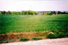
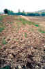
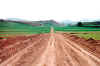
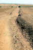
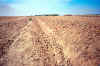
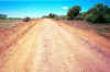
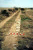
| Vía de Italia in Hispanias: The difference in the growth of the grain shows the existence of an underlying pavement of a roman road near to Libia in the "Rioja". Despite of being known by the villagers as "the Roman road", appear on the map of the province of Logroño (made by Coello in the year 1851) as "remains of a Roman road" and being named in modern maps "Roman Road", the direction of the process of re-allotment destined the road to be cultivated. |
|
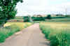
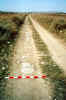
| Vía de Italia in Hispanias: The farmer of this field near to Lodosa in Navarra, doesn't know that the pertinacious gravel of the road he has decided to farm is of Roman origin. Yet he knows very well that the royal road passed along there before it was moved a little to the left. Still you can observe the back made up by the pavement |
|
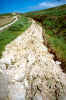
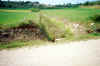
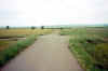
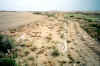
| Vía de Italia in Hispanias: The roman road, partly farmed in Cerezo de Riotirón (Burgos). You can see the difference in the growth of the grain. If it is not staked off soon, this road section of the road from Zaragoza to Astorga will disappear. |
|
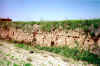
| Vía de Italia in Hispanias: The impressive embankment of the roman road is reduced bit by bit by the farming works in Cerezo de Riotirón (Burgos). |
|
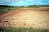
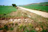
| Vía de Italia in Hispanias: Appearance of the old roadway of Briviesca in Cerezo de Riotirón (Burgos), June 1996. The roman road was farmed in spite of the evidential improductivity of the stony material hauled up. Supposedly there is a relation with the collection of agricultural subsidies, so trendy in these last years. |
|
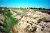
| Vía de Italia in Hispanias: The pavement of the royal road in Villayerno Morquillas (Burgos) farmed. The stones emerge still at the surface, in spite of being a very old cultivation, probably of the beginning of the XX century. |
|
| Vía de Italia in Hispanias: Appearance of the embankment of the Pilgrims road, in the municipality of Santas Martas (León). In the front it has been recently cultivated. Subsequently it shows abandoned and in the rear continues the road. Photograph of June 2000. |
|
| Vía Augusta, interior between Ilerda and Iulia Lepida Celsa: Stones at the surface of the alignment of the ancient Road of the Fierros in Bujaraloz (Zaragoza). The parcellation induced by the new irrigations of the Monegros in 1992 has eliminated the road. Madóz, in the tale of the population, considers this road being Roman. In front and behind these remains, others have been found that confirm this extreme. |
|
| Vía de Italia in Hispanias: Remains of the pavement of the roman road, sectioned by a drain and by the new road in Hurones (Burgos), caused by the realottment works in 1992. The road is called in the region and in all the existent cartography, "Road of the Romans". |
|
| Vía de Italia in Hispanias: Remains of the pavement of the roman road, sectioned by a drain and by the new road in Hurones (Burgos), caused by the realottment works in 1992. The road is called in the region and in all the existent cartography, "Road of the Romans". |
|
| Vía de Italia in Hispanias: Longitudinal section of the pavement between Calagurris and Barbariana brought about by the levelling of an estate. |
|
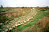
| Vía de Italia in Hispanias: Road section from Balsione to Cascantum in Navarra. On the map of López ( XVIII century), as well as on the map of the Province of Navarra from Madoz (1861), the road is called as "vestiges of a Roman Road". The new irrigations have profoundly transformed the landscape. Estates have been levelled and deep drains, as can be seen on the photograph, have been constructed destroying the roman road at many places. |
|
| Vía de Italia in Hispanias: The well known and pointed out on all cartography as "Road of the Romans" in the municipality of Azofra (La Rioja), was affected by the realottment of May 1997. In the rear the municipality and the village of Hormilla not yet affected. |
|
| Vía de Italia in Hispanias: The well-known and pointed out on all cartography as "Road of the Romans" in the municipalities of San Torcuato and Bañares, was paved over more than two kilometres in 1999. |
|
| Vía de Italia in Hispanias: The well-known and pointed out on all cartography as "Road of the Romans" in the municipalities of San Torcuato and Bañares, paved in 1999. In the rear it continues not paved. |
|
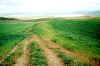
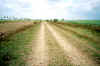
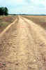
| Vía de Italia in Hispanias: The so-called "Pilgrims road" between Carrión de los Condes (Lacobriga) and Calzadilla de la Cueza (Viminacio) in Palencia, in 1997. The embankment was perfectly aligned, although the wheel tracks sometimes disappeared, before it suffered modifications. |
|
| Vía de Italia in Hispanias: The so-called "Pilgrims road" between Carrión de los Condes (Lacobriga) and Calzadilla de la Cueza (Viminacio) in Palencia. The embankment was cut out in many points and lost its alignment during an intervention in 1998. |
|
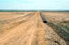
| Vía de Italia in Hispanias: Appearance of the "Pilgrims road" between Carrión de los Condes (Lacobriga) and Calzadilla de la Cueza (Viminacio) in Palencia, in 1997. The ditches at foot of slope, almost didn't exist. |
|
| Vía de Italia in Hispanias: Appearance of the "Pilgrims road" between Carrión de los Condes (Lacobriga) and Calzadilla de la Cueza (Viminacio) in Palencia, in 1998. |
|
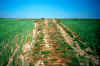
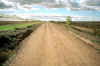
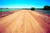
| Vía de Italia in Hispanias: Appearance of the high embankment of the "Pilgrims road" between Carrión de los Condes (Lacobriga) and Calzadilla de la Cueza (Viminacio) in Palencia, in 1997. |
|
| Vía de Italia in Hispanias: Appearance of the "Pilgrims road" between Carrión de los Condes (Lacobriga) and Calzadilla de la Cueza (Viminacio) in Palencia, intervened by motor graders in 1998. No material was added for the pavement. The existing materials were used and even part was wasted in several of the lateral cuts carried out. |
|
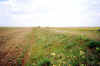
| Vía de Italia in Hispanias: Appearance of the "Pilgrims road" between Carrión de los Condes (Lacobriga) and Calzadilla de la Cueza (Viminacio) in Palencia. The pilgrims marked the lateral path they used. |
|
| |
|
| Vía de Italia in Hispanias: Appearance of the "Pilgrims road" between Carrión de los Condes (Lacobriga) and Calzadilla de la Cueza (Viminacio) in Palencia, in 1998. |
|
| Vía de Italia in Hispanias: The institutional information board that announces the existence of a Roman road in "Calzada del Coto (León)", didn't prevent it from being levelled and remodelled by motor graders in June 2000. |
|
| Vía de Italia in Hispanias: The Roman road, called Pilgrimsroad on all cartography, in Calzada del Coto (León), intervened by earthworks machinery in June 2000. |
|
| Vía de Italia in Hispanias: The Roman road, called Pilgrimsroad on all cartography, in Calzada del Coto (León), intervened by earthworks machinery in June 2000. You can recognise the width of the original pavement and the applied new width. Photograph, 10 june 2000.(See for an example the newspaper "La Crónica de León" june 15). |
|
| Vía Augusta, interior between Ilerda and Iulia Lepida Celsa: The road, of all ages, is sectioned by the new construction. Nobody becomes aware of the value of the found infrastructure? |
|
| Vía Augusta, interior between Ilerda and Iulia Lepida Celsa: Again the road sectioned. Nobody becomes aware of the value of the found infrastructure? |
|
| Vía Augusta, interior between Ilerda and Iulia Lepida Celsa: Idem. |
|
| Vía Augusta, interior between Ilerda and Iulia Lepida Celsa: Idem. |
|
| Vía Augusta, interior between Ilerda and Iulia Lepida Celsa: Idem. |
|
| Vía de Italia in Hispanias: The constructor that explored the gravel of this ancient embankment knew that there is no other in the region. Finally he decided not to use it. |
|
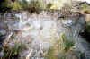
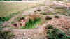
| Vía de Segisamone a Amaia: Roman road section excavated by the villagers of Sasamón, during a holiday, with the means to increment its attractiveness. Far from any scientifically method and archaeological control, the excavation left the base of the pavement, eliminating the wearing course that could have been conserved. (The underworld is full of good intentions). |
|
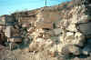
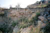
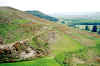
| Vía de Italia in Hispanias: Appearance of the road of Arrieros de Tardajos ascending to the Roman fortification of Deobrigula. The research work (Description of the road from Italia to Hispania, in Burgos and Palencia. Moreno Gallo, I.) handed over to "La Junta de Castilla y León" in November 1998, demonstrates the indisputable romanity of this road. |
|
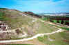
| Vía de Italia in Hispanias: Appearance of the road of Arrieros de Tardajos ascending to the Roman fortification of Deobrigula, after being cut for the building of a pipeline in march 2000. (See for an example the newspaper "el Diario de Burgos" Paper editions of march 15 and of march 16; digital editions of march 15, march 16 and of march 29). |
|
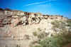
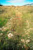
| Vía de Italia in Hispanias: Appearance of the Old Road from Burgos to Sasamón in Citores del Páramo (Burgos), in 1998. Very close to this place was discovered the "miliario of Villanueva de Argaño", in the place of "La Fuente del Rey". |
|
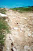
| Vía de Italia in Hispanias: Appearance of the Old Road from Burgos to Sasamón in Citores del Páramo (Burgos), in may 2000, after excavating a ditch for a new telephone connection, that destroyed a road section of more than one kilometre. (Also see the newspaper "el Diario de Burgos": The paper editions of may 19 and may 20; the digital editions of may 19 and may 20. The newspaper "ABC Castilla y León": The paper editions of may 19). |
|
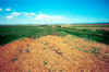
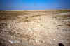
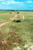
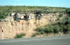
| Roman road of the republican age in the region of the Monegros, in Aragón. These vestiges don't have any protection. |
|
| Roman road of the republican age in the region of the Monegros, in Aragón. Idem. |
|
| Roman road of the republican age in the region of the Monegros, in Aragón. Idem. |
|