| |
THE ROMAN WALL OF LUGO

From the book "El informe Aió"
www.3dnauta.com
Ulises Sarry © 2002
TRAIANVS © 2002
THEORETICAL AND SCHEMATIC EVOLUTION.
The city was founded about the year 14 before Christ. Lugo grew in peace for two and half centuries. In view of the archaeological rests it must have been very prosperous and important. At that moment the Lucenses did not need a wall because they did not have any enemies. In sight of the invasions of the Barbarian people, the Romans built the wall that was to defend the city.
And three important and mysterious facts take place:
1.- Such a big wall left part of the city on the outside in exchange for an area of wasteland.
2.- The wall of Lugo has the biggest concentration of towersper linear metre of all the ones known.
3.-The wall is constructed following a design that does not seem to have been of military inspiration since it brings it near to the abandoned part of the citywhich is higher up above sea level.

Did the inhabitants of Lugo, "the Lucenses", end up paying the consequences of this error?
Everything seems to indicate that they did. But, if it happened nobody remembers it anymore.
The men and the culture that constructed it disappeared suddenly and definitively the year 460. Remismund and his army of Sueves entered the city that left the doors of the wall open during the Easter celebrations knowing that the enemy was still nearby.
The Sueves loved neither the thermal baths nor the sports.
The city held its importance during many centuries. It passed from one to another, from kings to caliphs (25 years), from counts to prelates and then lords and, according to the little that is known, it was always for the worst. Also there were long centuries of abandonment, neglect and desertification.
When the temples and palaces had long disappeared, the wall continued to have a good reason for being there because there are evidences of reconstructions. But it was often a borderline between enemies and the plundering of centuries managed to be institutional. In 1921, blown-up at night, a tower was knocked down for the opening of a new door. The same year it deserved the title of "National Monument". In 1920 it had been declared public quarry.
The majority of the Roman walls were eliminated by the gradual invasion of buildings, which were first semi-detached and later embedded within the wall.
In Lugo this phenomenon took place more slowly and with some lucky episodes: In 1809, the French army, for strategic reasons, burned and knocked down all the houses arranged on the outside. In 1971, in "The Clean Wall Operation " 72 houses that had appeared later were knocked down. One thousand and fifty eight linear meters of wall remained free on the outside (the wall is 2130 m long in all). The Operation supposed an investment of 1.688.844,01 Euros
Today the wall of Lugo is "heritage of humanity". But it continues suffering the insidious assault of "urbanism". The houses that surround it, both on the inside and outside, steep over it and minimize it and, even worse, the rain that has filtered through it for centuries, now flows with even more freedom thanks to the "massage" of the rapid traffic of heavy vehicles, which goes along a rigid road with sudden joints of expansion barely a few centimetres away.
Many different kinds of weeds refuse to be moved either with a sharp or cutting instrument. Nobody seems to know today that the Romans plastered the walls and houses to protect them from the rain.
The great lack of information about the Roman wall produces, often, inaccurate conclusions or what is even worse, denials. Example: (1992) Lugo, Great public exhibition of the archaeological local patrimony.
There was a big model of the wall and the city there (I believe it is still there kept as the monument to stupidity, I suppose). All the towers had two rows of windows without any horizontal useful space in between, three windows and above a scanty and unstable roof. Certainly these towers would not prevent the attackers from running along the adarve (see "Chinese Tower").
![]()
The soul of Rome disappeared and only that of the barbaric invaders seems to remain. But such a formidable fortress had to be the pride of the men who built it and the admiration of everyone that saw it for the first time from the distance.
Year 1557. The Licentiate Molina, itinerant fonctionnai of the King Philip II, says in two beautiful quatrains:
A wall like the one in Lugo, which was of Spain
A big and old city,
Or another fence, not even of half the size,
Is impossible for kings to build
two carts pass easily through it
of hard mortar the towers were made
with many windows that closed
its clear stained glass windows
![]()
![]()
The digital information allows a new form of observation. In this picture (04) a section of five towers has been selected and has been used as template. It is easy to observe that it adapts well in numerous points of the tracing. Another rule: nearly always when a wall was reconstructed, it lost uprightness and leaned outwards.
The ellipse North-South is also arbitrary and it only serves as help in the search of possible symmetries.
 |
 |
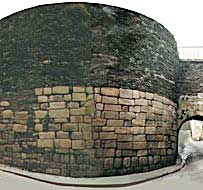
1.-The door of "the Carmen"(See photography): It is the most ancient door that remains and also the most beautiful. It is the only point where the curtain (straight wall) is much narrower. Is it the Mile or Km. 0 of the wall? Though probably there was another more important door, because the Romans were in the habit of establishing the main door there where the enemy could attack with the most facility... which does not seem to be very easy to understand, because a door is an intrinsic weakness. Point 5 would be a good candidate: opposite sun light and ground ascending in front.
2.- Spurious tower. It flanks the "New Door" (one of the most ancient). This door was extended in 1900 in an unfortunate way because it disturbed the adarve very strikingly. The false tower was cut by its vertical half and it is between two others which are at the right distance.
3.-Five spurious (?) towers. None fulfills the guidelines. The red points (as arbitrary, as the red clones) follow the norm. These towers are of a much smaller diameter, precisely in one of the places where the ground is favorable to the enemy (¡?). The wall here , seems to have suffered a great ruin being then moved a further metre towards the exterior with towers of minor diameter.
4.- "Redoubt Cristina", 1836. The houses had invaded the wall. The redoubt adapted the wall for the modern war, the towers were not necessary, many among them were ruinous and some were used to keep animals. For the first time a way out onto the path right at the top was opened so they could move pieces of artillery. Today it is a magnificent walk, if only rather depressing .
5.-All five towers are documented thanks to the military plan of the project. They all fulfill the guidelines. One was crossed diagonally by a new door (1888). Another one, which was recently discovered inside a house which was being done up, is now inside the new house that was built on top. The existence of such a tower was supposed thanks to the military plan on which a small piece was clearly missing. Three of these towers are today completely invisible.
6.- The place where 5 historical towers (1877) were mutilated to save the promenade of the canons. The amplification of the rampart walk had dwarfed the sidewalk. The main irregularity takes place where the wall comes closer to a higher outside piece of land: The abandoned city (see level curves). Could it have been that a big destruction followed by a reconstruction made the wall advance some 20 metres?
![]()
THE OLDEST PLAN OF THE WALL AND THE CITY (1760?)
The part belonging to the outside of the wall has been suppressed and it has been surrounded by the plan of the wall as it is today, to bigger scale for an easier comparison. (Both plans should be parallel).
It is in the Provincial Museum and seems to be a handmade copy of another one that is today missing. Because of the antiquity and the light to which it was exposed, now it is almost invisible. As far as the manuscript texts are concerned, some were already illegible when I photographed them in 1965.
Its little geometric accuracy (a characteristic of all the plans of the wall, including the 1/500 of today) does not reduce its great documentary interest. We can see, in blue, the aqueduct following the highest curve but then with a sudden detour of 90º, to go towards the Town Hall and towards the fountain of the main square, where it forks towards the missing Convent of Peace and to the Episcopal Palace (20).
The service routes to the gardens (28 and 29) are still today perceptible. The blue structures have not been identified. Although the houses were semi-detached to the wall it seems as if they had not yet become part of it. Also a ramp of access to the wall is observed, the cathedral (number 70 red) but it goes to another tower of flank. This tower seems displeased forwards and presente a different (?) morphology. From here it departs the "Great Irregularity"(?). This strange tower could very well be the one called " Nuriega or Noriega " which was used as an official house (?).
TEXTS OF THE MAP OF 1760 (written in Galician in the original)
1.- Porta do Carme o "Miñá"
14.- Rúa Falcón
15.- Praza da Pinguela
16.- Praza do Campo
17.- Rúa Nova
18.- Rúa San Francisco
19.- Rúa Batitales ( alta concentración de mosaicos )
20.- Rúa do Palacio
21.- Rúa dos Clérigos
22.- Casa da Corona
23.- Carril das Campás
24.- Carril do gato mouro
25.- Eirexa refuxio
26.- Cementerio do Hospital
27.- Calexón de Ramelle
28.- Calexón das Estantiguas
29.- Calexón do Sestoiro
In the following plan we have the current city surrounded by the wall of the 1760 plan, which has been restored dimensionally (now they are a bit more parallel).
![]()
On plan we have the outside wall of 1971 with the attached houses and some towers less. Inside ( in orange): The wall of the plan of 1760. And within the wall and the city of today.
![]()
At this moment I was looking for the real number of towers of the Wall of Lugo. Number of which I have not yet been able to discover for lack of any another archaeological exploration in the nearness of the "great irregularity" (The door of the Cathedral) and because the plan of 1760, apart from having bad geometry brings us to another fact that seems to invalidate it completely:The total number of towers, 85, coincides with the total number of another two plans ( 85 arrows). But in the section between the "Door of Carmen" (Km. 0) and the "New Door" (with the tower cut away in 1900) the plan of 1760 shows 22 towers when everything indicates that there should have been only 21.
Although the main and big symmetries that the wall still shows, allows us to defend the theory of 81 towers with great accuracy it is necessary to give, as we shall see, a few small jumps.
The black arrows indicate the towers were returned to a place which was not the original one.
The red arrows mark the towers reconstructed in the place of others that are missing.
The green arrows are towers rounded after 1971.
The blue arrows, have not changed after 1971.
The purple arrows are historical towers all of which were victims of urbanism.
The light blue ones (bigger) only appear in the 1760 plan.
![]()
IDLY IN SEARCH FOR THE NUMBER OF TOWERS
1.- Door of "the Carmen" or " Migná " (of the Migne river) Possible km 0.
2.-Tower blown up with dynamite (1921). The Door of "The Bishop Odoario" stands in its place and is the biggest and most modern of them all. More modern = bigger. The design of the adarve was modified just a little. Sufficiently enough to slightly spoil the theory of the straight sections that bend towards two adjacent towers.
3.- Spurious tower. The door "Nova", in the North of the city, enlarged in 1800. A very important disorder of the adarve.
4.- Tower slightly moved in 1971, it had disappeared, the enlargement of the door of Saint Fernand stole its site. The aqueduct entered through here.
5.- Narrower towers, not up to standard, the green ones follow the model, but they are arbitrary.
6.- "Redoubt Cristine" and 5 informed towers.
7.- Door of "the Bishop Aguirre" (1894). Two towers disappeared. The wall weakened and made them fall outwards. This was repaired with the light intention of making it look obvious. Here weeds grow badly.
8.-"The great irregularity"
9.-Door of "the Cathedral" or of "the Santiago". Strange tower certainly very displeased towards the front.
10.-"The promenade of the canons.
Once decided upon where the point " Km.0 " is, I searched for its antagonist making the black arrow pass through the center of the arbitrary ellipse (North - South) up to the other side. Later I continued in a clockwise direction so as not to find myself with the irregularity too soon... The red arrows are limited to passing through the centre of the ellipse and the green arrows are simply correlative.
And a beautiful coincidence appears.
![]()
A CENTER, THREE TEMPLATES AND ONE THEORY
The use of templates allows simple and rapid comparisons taking advantage of the fact that they look like two very possible evidences: The existence of a center and an undoubted Roman regularity.
Here, three different insoles have been used: A, B and C. They have been copied and been made to turn by the axis "Z" to place them in a new place.
Clone C coincides with great perfection.
Clone A has possibilities.
Clone B doesn´t look bad but is right on top of the biggest mystery of Lugo's Roman wall.
![]()
THE THEORY WRITTEN OUT NEATLY
![]()
THE REDOUBT "CRISTINA" AND THE MILITARY PLANE OF 1836
The plan shows two projects, but another different one was built. The tower discovered in 1996 came as a complete surprise when a neighbour requested and obtained permission to some alterations... But it was predictable because also it fulfills the guidelines. But not the towers which continue towards the right, much more narrow and numerous.
Below the virtual space of the plan.

THE REDOUBT "CRISTINA" (2)
A. - Overlapping tower of three floors (?) on the virtual, and theoretical space, of the military plan.
B. - Overlapping in the virtual space of today.
C. - The same zone for the interior (1970). 9 houses have been suppressed for a more explanatory vision. Nowadays this house, called at one point or other "House of the Crown" has changed drastically.
![]()
![]()
![]()
THE HEIGHT AND IMPORTANCE OF THE TOWERS
The height and number of floors that the wall had in the good old days remains a mystery. It is not also known like and of what the roof was done because remains of tiles have not appeared. However if appear there plentiful rests of coal (the wall had around many attached houses dedicated to forges, bakeries and taverns). Pieces of glass also appear. Could they by any chance have been part of the stained glass windows "of great clarity" of which Licentiate Molina speaks?.
But, for roofs, Lugo has big deposits of good quality flagstone, the same as was used in the building of the walls and which has proven itself good and strong. The absence of foundation of the wall does not seem to have been an error either.
The curtain wall is the weakest point of the barrier. Its section shows two independent walls with a common base. Big slabs of both penetrent in the material of burying of the least coherent composition. Where they are in contact we can see that the stones interweave which might indicate a system of drainage or fracture.
The curtain wall seems to have been designed to be opposed to the irresistible assault of the enemy. The outside wall would always collapse preventing the enemies assault on the second wall. Filon of Byzantium, known engineer of the antiquity, said in a written manual of artillery 200 years before JC. That a wall should have a minimal thickness of 4,62 m. to be able to support the missiles thrown by a catapult and that we should keep these machines at a distance, of at least 150 m. by means of pits and other obstacles. The the wall in Lugo is even wider than recommended.
But to have strong, high and close towers was the best thing that a wall could have.
MORE EVIDENT REASONS
1.- The number of garrison soldiers could decrease enormously.
2.- It facilitated the flattest and most precise shot of the catapults of which there existed multiple models that were made in series, as were the rest of weapons and equipment. The light ones or "scorpions" and the "lances - javelins" of superior size. Both throwing, with great force and precision, aerodynamic darts with a steel tip. They could be aimed by day and shot by night. They were moved about dismantled.
3.- If a heavy weapon or a tower of assault came closer to the walll, it would be knocked down by means of the gaffs and the pulleys. With the same technology of "Botafumeiro" (big incensaire ) of the cathedral of Saint Jacques de Compostelle, a high tower could throw the gaffs further away, undoubtedly to more than one tower. If the flank towers were active it would be very difficult to attack the curtain wall.
4.- If everything else failed, the towers were dismantled to build a third wall of reinforcement, to hurl stones to try and stop the advance of machines of assault or simply as manual missiles.
The wall on the insde has a different section to the one on the outside and the careful treatment of its stones indicate any thing but haste. (see circle)
All the towers have a back stair (even some of the spurious ones). The majority were surely refilled when the wall was adapted for the modern war (1836) After five frontal steps it forks out in two narrowrt wings. Undoubtedly what they were looking for was to achieve a good way through without debilitating the tower too much. They would need stairs... maybe be a drawbridge with steps?
The towers had two doors of access to the adarve, apart from the one at the back. These two doors were made narrower (?) to make them more solid and difficult to attack. With its three closed doors, the tower became a true bunker. The Roman did not seem to be in a hurry but they seemed to be afraid... After all, losing the battle meant losing ones life or ones freedom.
The providential engraving of 1850 contributes with important information: The windows are framed by stone ashlars and their vertical separation is very small. A height between floors of 3 metres would leave room enough for a legionary (they can´t have been shorter than 1,75 m.) to raise his heavy lance (Pila muralis) and to fire it down through a window without rail.
The engraving also shows, with just as much clarity, how the ruin of the towers took place. The straight walls (the towers had three) were more easily demolished. But the curved walls had also begun to suffer the advances of the ruin: A line of windows on each side did not exist anymore.
Is that when the Chinese tower appears?